|
| *****SWAAG_ID***** | 155 |
| Date Entered | 13/03/2011 |
| Updated on | 13/03/2011 |
| Recorded by | Tim Laurie |
| Category | Burnt Mound |
| Record Type | Archaeology |
| Site Access | Private |
| Location | Nanny Miller Springs- In pasture north of Rubbing House above Clapgate Plantation. |
| Civil Parish | Marske |
| Brit. National Grid | NZ 10781 01940 |
| Altitude | 253m |
| Geology | Spring rise below Richmond Chert strata |
| Record Name | Nanny Miller Springs. Burnt Mound Site 1 |
| Record Description | In pasture 300m NE of Rubbing House. Very large burnt mound. Roughly circular 11m diameter, the centre of the mound has recently been quarried away for hardcore. The burnt stone and charcoal/earth material of the mound is clearly visible. See photos. One orthostat survives and a vertical slab may be a surviving trough.
Two further burnt mounds, one large and one very small (Sites 2 and 3, MSK32 and 33) are located a few metres higher up at the same spring rise.
|
| Dimensions | 11m diameter* 1m High approx (part quarried) |
| Additional Notes | This burnt mound is a characteristic burnt mound type site. Site 1 is the lowest of three sites located in open pasture at a constant named spring and at an elevated viewpoint location. Unusually, Nanny Miller Spring rises above the Main Limestone which outcrops in Clapgate Spring Wood.
This quarried burnt mound site offers an opportunity obtain charcoal for C14 dating and to clean up and reveal the hearth and trough features which are usually concealed.
First noticed on Google Maps- see images attached. The Google image clearly shows this mound before the quarry disturbance.
|
| Image 2 ID | 428 Click image to enlarge |
| Image 2 Description | | 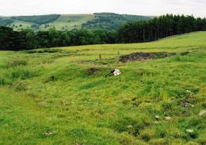 |
| Image 3 ID | 429 Click image to enlarge |
| Image 3 Description | | 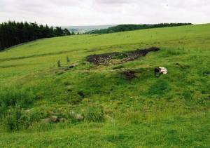 |

